SierraCamNetwork.com

Your webcam aggregator for the Sierra Nevada region ... view all our network webcams in one spot!
 
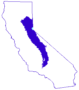
The Sierra Nevada mountain range stretches 400 miles (650 km), from Fredonyer Pass in the north to Tehachapi Pass in the south. It is bounded on the west by California's Central Valley, and on the east by the Great Basin.

View Mode: [Map / Thumbnails / Google Earth]

Live Thumbnails (updated every hour from sunrise to sunset):

Images are sorted in order by latitude, from north to south.

*click on a thumbnail for a full-size view of all cameras at that location*

Thumbnail - click to view Susanville: Town Hill, west of Susanville (elev. 4489 ft.)Thumbnail - click to view Susanville: SR36/SR44 Junction, west of Susanville (elev. 5041 ft.)Thumbnail - click to view Susanville: East Riverside Drive at the east end of Susanville (elev. 4205 ft.)Thumbnail - click to view Susanville: SR36/US395 Junction in Johnstonville, southeast of Susanville (elev. 4180 ft.)Thumbnail - click to view Fredonyer Summit: Westbound side of HWY 36 just east of Fredonyer Summit (elev. 5627 ft.)Thumbnail - click to view Janesville: West side of US395 near Janesville (elev. 4165 ft.)Thumbnail - click to view Feather River Canyon: SR70/SR89 Cam, located at Greenville Wye in the Feather River Canyon (elev. 2856 ft.)Thumbnail - click to view Doyle: West side of US395 two miles south of Doyle (elev. 4300 ft.)Thumbnail - click to view Bucks Lake: Bucks Lake (elev. 5161 ft.)Thumbnail - click to view Portola: Western Pacific Railroad Museum in Portola, CA (elev. 4836 ft.)Thumbnail - click to view West Lake Tahoe: Truckee Cam (elev. 5822 ft.)Thumbnail - click to view Lake Tahoe: Northstar-at-Tahoe: At the Summit (elev. 8610 ft.)Thumbnail - click to view Lake Tahoe: Diamond Peak Mountain Cam: At the top of Crystal Express lift, looking SW over Lake Tahoe (elev. 8540 ft.)Thumbnail - click to view Lake Tahoe: Snowflake Lodge Cam: Mounted at Snowflake Lodge, Looking NW over Lake Tahoe  (elev. 7440 ft.)Thumbnail - click to view Lake Tahoe: Ridge Run Cam: Mounted at Snowflake Lodge, looking east towards Crystal Ridge & Diamond Peak (elev. 7440 ft.)Thumbnail - click to view Lake Tahoe: Westbowl (elev. 6822 ft.)Thumbnail - click to view Lake Tahoe: View of Lake Tahoe (elev. 6822 ft.)Thumbnail - click to view Lake Tahoe: Top of Grandview Express  (elev. 6822 ft.)Thumbnail - click to view Lake Tahoe: Northstar-at-Tahoe: Mid Mountain (elev. 6822 ft.)Thumbnail - click to view Lake Tahoe: Huckleberry Canyon (elev. 6822 ft.)Thumbnail - click to view Lake Tahoe: Easy Rider Express (elev. 6822 ft.)Thumbnail - click to view Lake Tahoe: Backyard (elev. 6822 ft.)Thumbnail - click to view Lake Tahoe: 360º Smokehouse BBQ Deck (elev. 6822 ft.)Thumbnail - click to view Lake Tahoe: Diamond Peak Base Lodge Cam (elev. 6700 ft.)Thumbnail - click to view West Lake Tahoe: Truckee River at Tahoe City (elev. 6228 ft.)Thumbnail - click to view East Lake Tahoe: Spooner Lake XC Trailhead (elev. 7057 ft.)Thumbnail - click to view Topaz Lake: Topaz Lake RV Park LakeCam (elev. 5015 ft.)Thumbnail - click to view Bald Helibase: Looking NE toward Dardanelle (elev. 5776 ft.)Thumbnail - click to view Angels Camp: Angels Camp (elev. 1450 ft.)Thumbnail - click to view Angels Camp: Old PooleThumbnail - click to view Mono Lake: Mono Lake Webcam (elev. 6376 ft.)Thumbnail - click to view June Lake: View from the SW corner of Boulder Dr & Lakeview in June Lake, CA (elev. 7612 ft.)Thumbnail - click to view Yosemite: Yosemite Valley: View of Half Dome from Ahwahnee Meadow (elev. 3975 ft.)Thumbnail - click to view Yosemite: Yosemite Valley: Merced River at Happy Isles Bridge in Yosemite (elev. 4038 ft.)Thumbnail - click to view Yosemite: Yosemite Valley: View of Half Dome from near Sentinel Dome (elev. 8125 ft.)Thumbnail - click to view Yosemite: Views from Turtleback Dome: Looking to the West (elev. 5266 ft.)Thumbnail - click to view Yosemite: Views from Turtleback Dome: Looking at Yosemite Valley to the East (elev. 5266 ft.)Thumbnail - click to view Mammoth Mountain: Main Lodge Webcam (elev. 8923 ft.)Thumbnail - click to view Devils Postpile National Monument: Soda Springs Meadow (elev. 7567 ft.)Thumbnail - click to view Yosemite: Wawona Area: The Redwoods in Yosemite Vacation Rentals (elev. 4157 ft.)Thumbnail - click to view Fish Camp: View of Raymond Mountain from LoggerThumbnail - click to view Bishop Cam: Mt. Humphreys, Basin Mountain, and Mt. Tom as seen from Bishop, CA (elev. 4255 ft.)Thumbnail - click to view Bass Lake: Bass Lake: Looking South towards the Forks Marina (elev. 3380 ft.)Thumbnail - click to view Bass Lake: Bass Lake: Looking SE toward the SheriffThumbnail - click to view Sierra Summit Ski Resort / Huntington Lake: Sierra Summit Ski Resort ABC30 SkyCam (elev. 8490 ft.)Thumbnail - click to view Shaver Lake: View of Shaver Lake from Sierra Marina (elev. 5374 ft.)Thumbnail - click to view Shaver Lake: Shaver Lake Marina Parking Lot (elev. 5374 ft.)Thumbnail - click to view Shaver Lake: Shaver Lake Launch Ramp (elev. 5374 ft.)Thumbnail - click to view Sierra Remote Observatories: Sierra Remote Observatories (elev. 4625 ft.)Thumbnail - click to view Hume Lake, Buck Rock, and Park Ridge: Hume Lake (elev. 5205 ft.)Thumbnail - click to view Hume Lake, Buck Rock, and Park Ridge: Buck Rock: NW - Converse Mountain (elev. 8495 ft.)Thumbnail - click to view Hume Lake, Buck Rock, and Park Ridge: Buck Rock: NE - Lookout Peak (elev. 8495 ft.)Thumbnail - click to view Hume Lake, Buck Rock, and Park Ridge: Park Ridge: Looking W toward Dunlap (elev. 7542 ft.)Thumbnail - click to view Hume Lake, Buck Rock, and Park Ridge: Park Ridge: Looking SE - Big Baldy (elev. 7542 ft.)Thumbnail - click to view Hume Lake, Buck Rock, and Park Ridge: Park Ridge: Looking NW - Sampson Ridge (elev. 7542 ft.)Thumbnail - click to view Hume Lake, Buck Rock, and Park Ridge: Park Ridge: Looking E toward Shell Mtn. (elev. 7542 ft.)Thumbnail - click to view Mt. Whitney: View of Mt. Whitney from Lone Pine (elev. 3733 ft.)Thumbnail - click to view Giant Forest: Giant Forest in Sequoia National Park (elev. 6291 ft.)Thumbnail - click to view Three Rivers: Kaweah River at Pumpkin Hollow (elev. 1277 ft.)Thumbnail - click to view Three Rivers: Moro Rock and Alta Peak (elev. 1249 ft.)Thumbnail - click to view Three Rivers: Ash Peaks (elev. 1249 ft.)Thumbnail - click to view Mineral King: At the Silver City store near Mineral King (elev. 6854 ft.)Thumbnail - click to view Mineral King: Faculty Flat in Mineral King (elev. 7440 ft.)Thumbnail - click to view Mineral King: Mineral King Valley (elev. 7830 ft.)Thumbnail - click to view Mineral King: Farewell Gap in Mineral King (elev. 7830 ft.)Thumbnail - click to view Three Rivers: Looking NE up the Kaweah drainage toward Sequoia National Park (elev. 847 ft.)Thumbnail - click to view Jordan Peak: Looking W toward Lumreau Mtn. toward Springville (elev. 9103 ft.)Thumbnail - click to view Jordan Peak: Looking W toward Dennison Peak (elev. 9103 ft.)Thumbnail - click to view Jordan Peak: Looking SE toward Needles Lookout (elev. 9103 ft.)Thumbnail - click to view Jordan Peak: Looking NW toward Maggie/Moses (elev. 9103 ft.)Thumbnail - click to view Jordan Peak: Looking N toward Maggie Mountain and Vandever (elev. 9103 ft.)Thumbnail - click to view Jordan Peak: Looking E toward Hockett Peak (elev. 9103 ft.)Thumbnail - click to view Alpine Village, CA: Alpine Village NetCam - view south to Slate Mountain (elev. 6517 ft.)Thumbnail - click to view Springville: Springville - Looking SW (elev. 1030 ft.)Thumbnail - click to view Needles Lookout: Looking N toward Farewell Gap (elev. 8245 ft.)Thumbnail - click to view Bald Mountain: Looking West toward Sherman Peak/Sherman Pass (elev. 9388 ft.)Thumbnail - click to view Bald Mountain: Looking Southeast toward Dome Land (elev. 9388 ft.)Thumbnail - click to view Bald Mountain: Looking Northeast - Olancha & Mt. Whitney (elev. 9388 ft.)Thumbnail - click to view Bald Mountain: Looking North - Farewell Gap to Kern River (elev. 9388 ft.)Thumbnail - click to view Bald Mountain: Looking East toward Kennedy Meadow (elev. 9388 ft.)Thumbnail - click to view Sherman Peak: Looking Southwest toward Tobias Peak & Baker Pt. (elev. 9906 ft.)Thumbnail - click to view Sherman Peak: Looking Southeast toward Sirretta Peak (elev. 9906 ft.)Thumbnail - click to view Sherman Peak: Looking Northwest toward Smith Mtn. (elev. 9906 ft.)Thumbnail - click to view Sherman Peak: Looking Northwest toward Farewell Gap (elev. 9906 ft.)Thumbnail - click to view Sherman Peak: Looking North toward Kern River Drainage (elev. 9906 ft.)Thumbnail - click to view Sherman Peak: Looking East toward Kennedy Peak (elev. 9906 ft.)Thumbnail - click to view Tobias Peak: Looking SW - Sugarloaf Peak (elev. 8288 ft.)Thumbnail - click to view Tobias Peak: Looking SE - Split Mtn. (elev. 8288 ft.)Thumbnail - click to view Tobias Peak: Looking S - Sunday Peak (elev. 8288 ft.)Thumbnail - click to view Tobias Peak: Looking NE up the Kern toward Needles Lookout (elev. 8288 ft.)Thumbnail - click to view Kernville: N fork Kern River at Bull Run Creek 2¼ miles N of Kernville - Cam 3 (elev. 2725 ft.)Thumbnail - click to view Kernville: N fork Kern River at Bull Run Creek 2¼ miles N of Kernville - Cam 2 (elev. 2725 ft.)Thumbnail - click to view Kernville: N fork Kern River at Bull Run Creek 2¼ miles N of Kernville - Cam 1 (elev. 2725 ft.)Thumbnail - click to view Alta Sierra: Alta Sierra Ski Area at Shirley Meadows : Cam 4 (elev. 6615 ft.)Thumbnail - click to view Alta Sierra: Alta Sierra Ski Area at Shirley Meadows : Cam 3 (elev. 6615 ft.)Thumbnail - click to view Alta Sierra: Alta Sierra Ski Area at Shirley Meadows : Cam 2 (elev. 6615 ft.)Thumbnail - click to view Alta Sierra: Alta Sierra Ski Area at Shirley Meadows : Cam 1 (elev. 6615 ft.)Thumbnail - click to view Breckenridge: Looking S toward the Tehachapis (elev. 7537 ft.)Thumbnail - click to view Breckenridge: Looking NW toward Tobias Peak (elev. 7537 ft.)Thumbnail - click to view Breckenridge: Looking NE toward Lake Isabella (elev. 7537 ft.)Thumbnail - click to view Breckenridge: Looking NE toward Havilah (elev. 7537 ft.)Thumbnail - click to view Breckenridge: Looking NE - close-up of Lake Isabella (elev. 7537 ft.)Thumbnail - click to view Breckenridge: Looking E - Walker Basin (elev. 7537 ft.)Thumbnail - click to view Tehachapi: Mountainbase Cam (elev. 4042 ft.)Thumbnail - click to view Tehachapi: Oak Tree Golf Course #7-B in Tehachapi (elev. 4042 ft.)Thumbnail - click to view Pine Mountain Club: Sawmill Mountain/Mt. Abel (2) (elev. 5555 ft.)Thumbnail - click to view Pine Mountain Club: Sawmill Mountain/Mt. Abel (elev. 5555 ft.)Thumbnail - click to view Pine Mountain Club: San Emigdio Cam/Mt. Pinos (elev. 5555 ft.)Thumbnail - click to view Lebec: Lebec (Southernmost tip of the Sierra Nevada mountain range) (elev. 5960 ft.)Thumbnail - click to view Cuddy Valley: Looking East towards Pinon Pines (elev. 5285 ft.)Thumbnail - click to view Tejon Pass: Grapevine Cam (elev. 4266 ft.)

Text Links:

We are currently indexing 116 webcams from the following locations (listed in order based on latitude, from north to south):

Links to other Sierra Nevada Webcam Sites: